Overland Triathlon Epple/to/Dobel, Karlsruhe, Ettlingen, Albtal, Germany
Inspired by a 2018 YouTube video from US professional triathlete and great YouTuber Eric Lagerstrom in 2022 the idea of my own first overland triathlon started to grow in my head. But it took me until September 17th 2023 to finally perform it the first time. A pre-test included only cycling and running.
This overland individual and cost-free triathlon takes you from lake Epple to the northern Black Forest mountain Dobel. You could also call it a Cross-Triathlon, as cycling and running are on trails to a large amount. The course is close to the cities of Karlsruhe and Ettlingen.
Lake epple is a small lake close to Karlsruhe and open to the public. Swimming is explicitly allowed there, so this is an ideal start point to this small adventure. The cycling takes you from the Rhine river valley through some nice forest trails to the small city of Bad Herrenalb. Here you switch to running up to the Dobel mountain.
Everyone is welcome to try this triathlon her/himself and see how she/he bears this challenge. I would be pleased if you send me your gps tracking and or photos/videos. I will add them here on the website and include your results into the table below. Please let me know what you think of the courses and anything else you want to report.
As I performed this overland triathlon without any support, my T1 and T2 times have not been very fast - something to be improved the next time. And I think next time I can run faster. So I hope to be able to repeat this triathlon in 2024 and be at least 15 minutes faster. The FKT so far is 4:07:22 and you are of course invited to try and beat it.
For those who are interested, I provide all GPS tracks and some details of the course.
Swim, 800 m:
From T1 you can either swim across the lake or walk along the beach to the start. The start is at the far end of the accessible beaches.
From the start you swim to the white buoy and pass it on its right side. Be careful when passing as the steel rope for fixing is not very deep in the water. After you have passed the white buoy you swim along the first and the second beach nose. Then take a slight turn to the right, swim closer to the beach already heading to east. Then you head to the yellow buoys at the east end of the lake, optimally you head to the second yellow buoy from the left. From this buoy it is only 50 m to the beach where you prepared your T1.
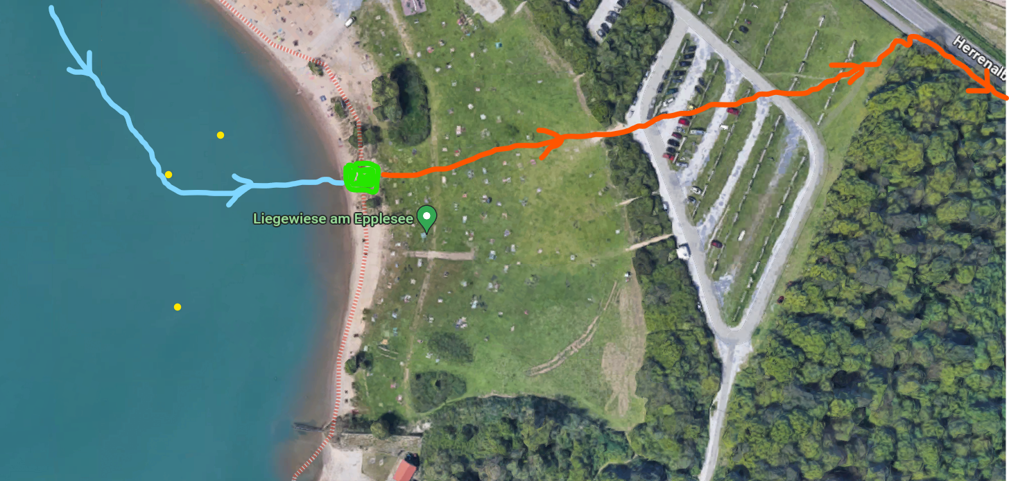
T1:
Probably you want to lock your bike - in case you don't have any supporters with you. Jump on your bike right at the beach and ride across the gras area up to the parking lot ... or if you feel more comfortable run across the gras area and jump on your bike only at the parking lot. Ride to East following the bike path, go under the train track and then take a 180 degree turn to the follow the tracks to South for a short time. Follow the GPS track.
You can download the GPS track for the swim here:
GPX
You can download the GPS track for the bike here:
GPX
Bike, 35 km::
The first 10 K are sort of a warm up, because they are flat. You will pass two other small lakes, then ride a little nature trail, before the first climb starts. There are some steep passages so make sure you chose the correct gear. Once you are on top of the first hill, you get a decent down-hill section, riding at the border of the forest, passing "Rimmelsbacher Hof", which is a nice cafe/restaurant for hikers and bikers to have a rest - but you of course don't have the time today. You might want to return another day.
Two short up-hills later (after 23 K) you will be on the "Death Man Trail", a famous trail in the region. Hope you are not yet dead by then, carry on with power, still 12 K to go.
You soon will be on the "Earl Rhena Path", which is then quite flat and with easy gravel, beside one short climb close to the "Monastery Frauenalb". Once you come to the town "Bad herrenalb" take a turn to the right on the first road you get to. In "Hardtscheuer" just in front of the golf club building you take a turn to the left into the "Kirchenweg". After a short technical as narrow downhill you go the last uphill section, before arriving at the train station. Here you park (and lock) your bike and switch to the run.
T2:
T2
I figured out, the bike parking (it is located north of the train station) here is a good spot, if you do this triathlon by your own: if you take the bus from the finish down to "Bad Herrenalb" again, it will bring you directly back to T2. And then you can take the train back towards the direction of Karlsruhe.
You can download the GPS track for the run here:
GPX
Here is also some small report of my first performance of that "Overland Triathlon Epple to Dobel":
As this first time I did the whole overland triathlon on my own without any support, I had put my bike at the beach for T1 and locked it with a light-weight lock. From there I walked the main part on the beach to the starting point. After I completed the swim, I completely changed to a dry tri-suit, a bike jersey ontop and socks, because air temperature was quite low this morning. Changing took me quite a long time, as you can see in the time splits below. I had a little knapsack prepared for T1, where my running shoes, some money and one powerbar had just enough space. A second powerbar I carried in the bag of my jersey. - And off I went for the second stage.
You can find the course also here:
Swim:
T1
Bike:
Run: